Yaak River Road reopened to traffic
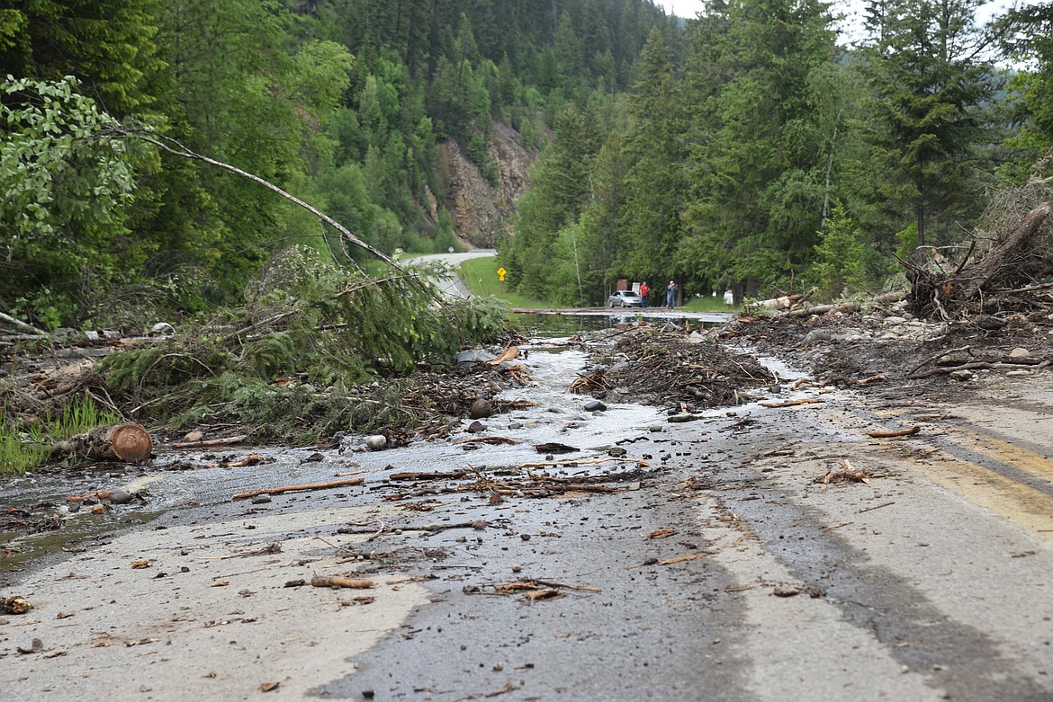
Debris from a rock slide is piled up on the Yaak River Road Wednesday evening in Lincoln County. Heavy rain caused slides that left mud, tree branches and rocks on the road at Yaak Falls. (Scott Shindledecker/The Western News)
Some roads remain closed in Lincoln County after heavy rainfall created conditions earlier this week in Northwest Montana.
According to the Montana Department of Transportation, Yaak River Road, also known as National Forest 508, is now open with a reduced speed limit of 35 miles per hour in the Yaak Falls area.
The road was closed as late as Thursday afternoon, but people were seen driving through the closure signs and the debris Wednesday evening. Officials announced the reopening of the road at about 4 p.m.
Lincoln County Emergency Management Director Thomas Lane previously said the state still had control of the road on Thursday and that there weren't enough staff to keep people from driving through the area.
"We are recommending people don't drive through that area because there is a lot of water pushing on that cliff and we're concerned about the instability there," Lane said. "If that cliff were to come down when a vehicle passed by there, it could be really bad.
"But we know folks in the Yaak are pretty hardy so it's a risk that some will take," Lane added.
Lane also said a drone flight was done in the area to help determine how unstable the cliff may be and what work may have to be done.
The Lincoln County Sheriff’s Office issued a Code Red alert to residents in the Yaak River Road and Eastside Road/National Forest 176 areas Tuesday. The Eastside Road is closed from mile marker 6 to 17 due to washouts on the road.
Lane said Eastside Road is still closed and he doesn't know when it will open. He also said there were no reports of residential flooding Thursday at noon.
“As always, we are telling folks to not drive, walk or swim through flood waters,” Lane said. “It’s better to turn around than have something bad happen. We’re also recommending people not drive into these areas to see what’s happening. It can be dangerous and hamper efforts of those who may be working in the area.”
Lane said work by the county on a bridge across Parmenter Creek in the Libby area helped it avoid flooding.
"We got a permit from (Montana) FWP to do a dig out on the bridge and allow the sediment to flow correctly," Lane said. "Without it, we could have had more trouble there. County road crews also did a good job in the Eureka area cleaning out culverts this spring and that prevented some potential problems."
Lane also said it's a good idea for private property owners to check on culverts to keep them clear. He added that a disaster declaration would depend on the cost of the damage.
According to officials at the Three Rivers Ranger District of the Kootenai National Forest, crews are working to assess road conditions in the area.
Kilbrennen Lake Campground, northwest of Troy, is currently inaccessible due to road conditions resulting from flood waters. Kilbrennan Lake Road is closed one-quarter mile past National Forest 752 due to flooding road conditions.
Also, a slide on National Forest Road 5996 closed it.
Kootenai National Forest officials are asking people to use caution when utilizing any forest roads or trails during times of high runoff.
According to the National Weather Service, the Yaak River near Troy was flowing at 8.68 feet at 2:45 p.m. Tuesday. Flood stage on the river is 8 feet.