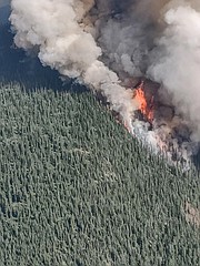
Evacuations ordered in face of South Yaak Fire
Crews battling the South Yaak Fire worked in recent days to safeguard houses and other structures near East Side and Kilbrennan Lake Roads as the blaze grew to 4,152 acres.
Despite promising progress against the wildfire early in the week, the South Yaak Fire flared up again on Tuesday, expanding by nearly 1,400 acres as it spread rapidly downhill and across slope. Officials said the expansion underscored the extreme fire danger since it occurred during a period of cooler weather.
As of July 28, the blaze surpassed the Burnt Peak Fire, reaching 3,382 acres with 20 percent containment.
As the blaze continued to spread, Lincoln County Sheriff’s Office rescinded then reissued evacuation orders for residents living along Kilbrennan Lake Road on July 27 in rapid succession. Authorities also issued a new evacuation order for residents along East Side Road that afternoon.
Officials with the Great Basin Type 2 Incident Management Team, which is overseeing both the South Yaak and Burnt Peak fires, reported that the Kilbrennan Lake Campground and Yaak Mountain Lookout remain in good condition.
Fire managers said the blaze had reached both sides of Kilbrennan Lake. Still, it was 20 percent contained with nine engines, two dozers and 163 personnel working the blaze as of Thursday morning.
To protect private properties, firefighters turned on pumps and hoses and continued digging fire lines and conducting burnouts. Crews patrolled established containment lines near the southern end of the fire to keep tabs on any fires caused by rolling vegetation. Officials also said resources were being shifted from the Burnt Peak Fire to the South Yaak Fire.
The Burnt Peak Fire was burning at 3,097 acres as of Thursday. Fire managers said the blaze was 31 percent contained. Three helicopters, nine engines, three crews, two dozers and 245 individuals were on scene.
Light rain, cloud cover, cooler temperatures and higher relative humidity helped moderate fire activity on July 27. The blaze grew around 200 acres that afternoon, primarily expanding to the north. Officials said the fire began backing down the north side of the peak where vegetation is dense and the terrain is challenging. Firefighters continued building contingency lines along Iron Creek and the ridge to Grouse Mountain.
The Ruby Fire, also outside of Troy, was 95 percent contained as of Thursday morning. One engine and 40 personnel were assigned to the 86-acre blaze. Officials said firefighters were using infrared technology to search for heat pockets.
As of July 26, wildland firefighters were battling 19 large fires in Montana, according to a statement from Gov. Greg Gianforte’s office. The northern Rockies region is the top priority region in the country and the state remained at preparedness level five.
Since the beginning of the year, Montana has seen 1,600 fire starts that have burned about 220,000 acres. In July alone, the state saw 600 fire starts. Officials have already spent nearly $13 million on fire fighting efforts since the start of Montana's fiscal year. The state officials began the fiscal year with Montana’s Fire Suppression Fund set around $105 million, the statutory maximum.


