No headline
UPDATE 8:42 p.m.: The overnight weather forecast from fire command was for “extremely poor overnight humidity recovery” within mid-slope thermal belts that would “likely keep the atmosphere unstable throughout the night,” spokesperson Jennifer McCully reported via Facebook Messenger at 8:19 p.m. Minimum temperatures were expected to be 50 to 60 degrees, she wrote, while 20-foot winds from the southwest at 5 to 10 mph in the evening were expected to later shift downslope/down-valley at 2 to 5 mph. Ridgetop winds blowing west at 15 to 25 mph were forecast to shift to the southwest at 5 to 15 mph. Resources assigned to the fire Saturday evening included five engines, two initial attack squads, 10 miscellaneous overhead units, two clippers, a type II dozer and a skidder, McCully wrote.
UPDATE 7:52 p.m.: About 7:45 p.m., a post to the Lincoln County Emergency Management Agency Facebook page stated pre-evacuation warnings were issued for Pipe Creek Road from Forest Way through Blue Mountain Lookout Road and Doak Creek Road; Bobtail Cutoff including Winter Road and Whitetail Road; and Creekside to 17 Mile Road. “Due to the lack of landlines, please check with your neighbors to ensure warnings reach everyone,” the post states.
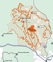
UPDATE 5:18 p.m.: Story updated to include map of Forest Service road and trail closures.
UPDATE 5:01 p.m.: Story updated to reflect latest estimate of fire size at 900 acres and note to be aware of fire equipment staging at J. Neils Park.
UPDATE 4:52 p.m.: Story updated to reflect announcement of Kootenai National Forest road and trail closures.
UPDATE 12:30 p.m.: Story updated to reflect latest estimate of fire size at 800 acres.
UPDATE 10:51 a.m.: Search and rescue personnel are “going door-to-door” to give pre-evacuation notices to about 50 homes “up in the end of the Bobtail Road area,” Lincoln County Sheriff Roby Bowe said in a phone interview shortly before 10:45 a.m. Saturday.
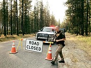
Authorities are asking people to avoid roads in the Quartz Creek/Bobtail Ridge area in the Libby Ranger District as agencies respond to the West Fork fire, according to information posted 9:30 a.m. Saturday to the Lincoln County Emergency Management Agency Facebook page.
The Lincoln County Sheriff’s Office is asking people to avoid the Kootenai River Road, Quartz Creek Road, Quartz Mountain Road, Bobtail Road and Bobtail Cutoff areas.
“Please stay clear and away from the Quartz Creek/Bobtail area, unless you have a residence,” states a 10 a.m. Saturday post to the Sheriff’s Office Facebook page. “Unnecessary traffic limits people from doing their job correct and fully.”
Later Saturday afternoon, the Kootenai National Forest announced numerous trail and road closures in the vicinity of the fire.
The West Fork fire was reported 10:48 a.m. Wednesday, according to a Kootenai Interagency Dispatch Center website. A fact sheet released shortly before 5 p.m. Saturday lists its size at 900 acres and warned people using J. Neils Park to be aware of the fire equipment being staged there.
“A local Type 3 Fire Response Team is in place providing for fire suppression strategies,” states the fact sheet. “The team’s focus is to get an accurate size up of the fire with weather dictating line construction activities. Hot and dry weather conditions will continue over the coming days make the fire active.”
The Emergency Management Agency post also notes today being the start of archery hunting season, and asks hunters to “please avoid active fire areas.”
Friday evening the fire was a dramatic backdrop to the Libby-Corvallis football game at Libby High School. Area residents posted to various Facebook pages photos and footage from various locations of billowing smoke that glowed orange at its base.


