Forest Service opens hiking trails


The Tree Rivers Ranger District recently cleared 21 trails. Among them is the Old Highway 2 Interpretive Trail.
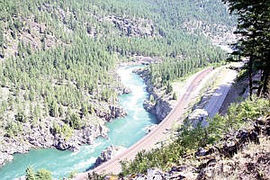
The Old Highway 2 trail is approximately 2.3 miles long and offers scenic views of the Kootenai River. The Three Rivers Ranger District gives the trail a difficulty rating of easy.
While hiking the trail one is surrounded by nature and history. There are many tiny springs. The trail passes through a closed environment of softwoods and mosses. In the open environment the hiker has views of the Kootenai River.
The trail is part of the old highway between Libby and Troy. The journey begins on Montana Highway 56 and comes to an end at the picnic area at the Old Highway 2 biking trail.
“It’s very educational, very scenic; you can see a good portion of the Kootenai Falls,” Dave Thorstenson, Three Rivers District Recreation Manager. “Plus there is a short trail connected that takes you to Shannon Lake. Those are three big things right there.” It’s educational, scenic and has other opportunities. It’s a good trail to take your family on.”
For the historic side of the trail, there are stopping points along the trail with historic information about the trail. At the very beginning of the trail there is a sign that reads:
“Historic Highway 2 Trail: A Road Through the Past. As you walk up this road, you will be walking back through the past. Time has erased many of the features of this narrow mountain road. If you look carefully along the way, though, you will find clues to help you imagine what it was like to drive the road in those early days.”
The sign continues. “The landscape around you has been erased and rebuilt over millions of years. Look closely for evidence of the monumental forces that heaved and layered the mountains into place. Watch for the distinctive features carved by glaciers and floods. You will even see remains of one of the earth’s earliest life forms captured in the rock along this trail.”
The Old Highway 2 Interpretive Trail is just one of many trails that you can enjoy that the Three Rivers Ranger District has recently cleared. One of those trails can be accessed from the Old Highway 2 Trail. The Shannon Lake Trail is a mile hike and is given a difficulty rating of moderate. The trail takes you to the small lake between Old Highway 2 and Grambauer Trail.
Ross Creek Nature trail is another short trail that has been cleared recently by the Three Rivers Rangers District. The trail is a mile long and is given a difficulty rating of easy. The trail has signs along the trail that give the hiker information about the plant and animal species in the grove.
For another historic and scenic trail, Thorstenson suggests Callahan Historic Trail.
The Callahan Historic Trail is two miles long and is given a difficulty rating of easy. It follows the old railroad grade that was once used for logging and mining. It offers views of King Mountain and Pulpit Mountain.
The Grouse Lake Trail is good for those hikers that are looking to do some fishing. The trail is 1.3 miles long and is given a difficulty rating of easy. It can be accessed from the junction of Highway 2 and Lake Creek Road.
“We have several smaller trails up at the Yaak that are very cool and scenic. Burke Lake is scenic and Northwest Peak Lookout is very scenic,” Thorstenson said. “Another scenic trail is Fish Lakes.”
The Burke Lake Trail is 1.3 miles long. It’s surrounded by trees with a view of Northwest Peak. The Northwest Peak Trail is 2.3 miles long. “It’s a great trail if you are looking for a good hiking experience in the forest,” Thorstenson said.
The Three Rivers District received help with the clearing of trails from the Montana Conservation Corps.
“They were out here for 10 days,” Thorstenson said. “They helped open up Kootenai Creek, which is directly above Kootenai Falls. They also helped us open Pulpit Ridge, which is a national recreation trail.”
The Kootenai Creek Trail is 2.5 miles long and offers views of the Kootenai River and Kootenai Falls.
For mountain biking Thorstenson recommends the pulpit trails.
“We are working on biking,” he said. “Biking is an activity that historically hasn’t been acknowledged in this area.”
But Thorstenson believes that’s changing. “There are some biking groups that are starting to form. What we want to do is hopefully get a mountain bike park in the area. So we are working towards that,” he said.
The Pulpit Mountain National Recreation Trail is a five-mile hike.
“The trail offers nice views all along it,” said Thorstenson.
For mountain bike enthusiasts the Three Rivers Ranger District has eight trails worth trying. They are broken down into category by difficulty. There are four moderate trails; Wood Mountain, Caribou, Henlsey Hill and Fowler Creek. The West Fork Yaak River and Spruce Lake offer more of a challenge. The West Fork Yaak River is 6.2 miles long and the Spruce Lake Trail is five miles long.
For a true hiking experience Thorstenson suggests the Pacific Northwest National Scenic Trail. The trail starts in Glacier National Park and travels west for 1,200 miles until its ending point on the west coast near Cape Alava, Wash.
“It’s relatively new as far as a true hiking opportunity, like the Pacific Crest trail or the Appalachian trail,” Thorstenson said. “It starts in our district in Boulder Mountain and goes through Rock Candy Mountain. It’s pretty sweet. I don’t think a lot of people know about it yet.”
Thorstenson and his crew are currently working on clearing more trails. They hope to have Upper and Lower Hawkins Lake Trails open soon. “The plan is to let the community know when we’ve cleared trails,” Thorstenson said. They’ve already cleared over 50 miles and hope that hikers will take advantage of their handiwork.