Anatomy of a prescribed forest burn
Humans have a complex relationship with fire. It can act as a life-saver or life-taker depending on the circumstances. For years, forest fires were believed to be a destructive force to be snuffed out as soon as possible. Times have changed.
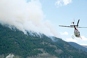
On April 21, the Kootenai National Forest carried out a 925-acre prescribed burn on the Rocky Gorge area along the east side of Lake Koocanusa. Numerous personnel from two Kootenai Forest districts and a crew from Minuteman Aviation Inc. of Missoula worked in collaboration to tackle the multi-objective project. Also, two mechanical engineers from the Missoula Fire Sciences Laboratory had placed sensors on the hillside to gather data for their research.
The burn was a pet project for Fuels Fire Management Officer Warren Appelhans.
“The main objective is to reduce the fuels and to support rejuvenation of browse for wildlife,” he said from the staging area across the lake from the burn. “And because we have the opportunity we can help the fire lab get more data. This is the fun part of it. I like the coordination of it and working with the different entities. Finally seeing it come to
fruition and being able to see the results afterward is something I enjoy.”
The goal was to reduce fuels by 90 percent and limit the mortality of trees larger than three inches to 10 percent.
Planning for the aerial ignition started more than a year ago to ensure compliance with federal regulations. The burn boss for the project, Fuel Specialist Harmony Burow, was in contact with all the players over the radio and stationed on the west side of the lake for the most of the day.
“During the planning process we’ll get together all of the specialists including the tree, fuels, fish, wildlife, archaeologists and recreation people; basically everybody in every aspect of forest management,” Burow said.
Burow’s day started at 6 a.m., then a helicopter support team from Libby, two engine crews from Eureka and Appelhans and Burow joined her around 10 a.m.
Before the helicopter took to the air and the teams deployed to their positions, Burow led a briefing about weather conditions, procedures and addressed how any contingencies would be dealt with.
The crews stood by along Highway 37, one at each end of the burn area. They also visited the nearby campgrounds to alert people about the burn.
The contracted helicopter crew arrived at 11 a.m. and loaded up the hopper that would dispense the ping pong-sized balls used for ignition to the forest floor. The spheres contain potassium permanganate and are spiked with glycol as they are distributed.
Senior Firefighter Aaron Marvin explained how the ignition dispenser operated. “Depending on how much the glycol goes in determines the ignition point,” Marvin said. “We like about 25 seconds or so after it’s punctured to where it’ll start igniting, that way it has plenty of time leave the aircraft. At the high setting you can be pumping out 175 balls a minute.”
As the helicopter swept back and forth laying down igniters from top to bottom, Burow, Appelhans and the two engineers from the fire lab, Dan Jimenez and Jason Forthofer, sat just off the highway a mile or so south of the morning meeting point.
Jimenez and Forthofer had a camera trained on the hillside taking pictures which they would later turn into a time-lapse video.
Jimenez’s research this day revolved around fire fighter safety zones. “The standard that is currently used to identify a safety zone is four times flame height,” Jimenez said. “Or you can say flame height is twice the vegetation height.”
Jimenez said those standards that came out in the 1990s have some limitations based on the assumptions made. “Mostly the fact that it accounted primarily for radiant heat and flat terrain and there’s a couple of reasons for why that is,” he said.
But those assumptions don’t fully account for the dynamics of a wildland fire. Variables like sun, wind and the degree of a slope are all factors that can alter a fire’s behavior.
Gasses from wildland fires can be extremely hot and are capable of causing severe respiratory damage to firefighters. “So we’re starting to look at what is the convective component on slopes under different fuel types and how does that affect the current safety zone standards,” Jimenez said.
The Rocky Gorge burn allowed Jimenez the opportunity to try and get data in a heavily fueled, steep slope terrain that can be used to validate the model predictions their starting to put together.
Forthofer’s objective for the day was to gather data about spread rates of fires.
“The model that’s used pretty much throughout the world is a model that was developed at the fire lab, but it’s 40 years old now,” he said. “A lot of those limitations cause it to be inaccurate in a lot of situations. And the most important situation you might say is crown fires.”
Crown fires spread through the canopy of a forest, rather than along the surface. They create the most dangerous and disruptive fires and are the most difficult to control.
Forthofer’s research is also looking at convection heat transfer and how it influences the spread of forest fires. “The spread-rate models we’re working on are used for more planning things,” he said.
The models would be used to determine if a fire can be allowed to burn without suppression efforts or, if they don’t act, will it jump to areas that need protection.
The Rocky Gorge burn on Tuesday was the third at that locationwith the most recent in 2000. Applehans said low-intensity fires, like they carried out, try to mimic naturally occurring fires. After years of putting out forest fires without considering the benefits, forests became choked with fuels, causing high-intensity fires to decimate areas of forest.
Appelhans said the Rexford District tries to perform one large aerial burn each season. Last year it was in the Peck Gulch area and next year they’re looking at the McGuire Creek area.
Appelhans said a little more sun and wind would have been ideal, but from the looks of things the following day all of their objectives had been met.
It will be a couple of days until the fire lab folks discover how the fire reacted with their recording instruments, but from their preliminary observations things looked promising.
“When we do this on our terms we can control the variables,” Appelhans said. “Whereas in lightning storms it’s on nature’s terms, not ours. So we’d rather do it on our terms.”


