WN Hiking Series: Enjoying view from old Highway 2
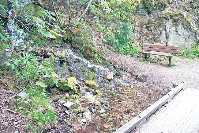
Brad Fuqua/The Western News Hikers on the Old Highway 2 Interpretive Trail will find springs and cascades along the way.
A good way to enjoy views of the Kootenai River in the area around the falls while learning about the region’s history and natural features is to go on a hike down the Old Highway 2 Interpretive Trail.
This section of the old highway features a trail that can be accessed easily from either end. The west trailhead is located in the Shannon Lake Road parking area – accessed a few miles south of the U.S. 2/Bull Lake Road junction. Or, you can find the east trailhead from a parking area on the right side of the road just past Kootenai Falls as you head toward Libby.
The route is part of the old highway that was constructed between Libby and Troy. Informational signs give hikers a true education about natural features, plant life and animals, and history of the old highway itself (including one sign with several quotes from The Western News). Benches can be found in many spots along the way for those who want to rest and enjoy the view.
Along the eastern section of the trail, hikers will find very nice views of the Kootenai River below while listening to the falls in the distance. Small springs will be found, including a photogenic cascade located roughly at the midway point where you can rest on a bench or kneel and splash some cool water on your face.
Keep your eyes open in the rocky areas for the possible viewing of a pika. You may even be entertained near the western trailhead by a loud osprey nested on a transmission line post. The various types of wildflowers and mosses complete the experience.
This is the type of trail that would be perfect for a family, even those with smaller children, or those who want to give the dog a little exercise. In some spots – especially on the eastern end – you’ll hear Highway 2 traffic below along with the occasional train – so not all the sights and sounds are strictly natural.
The trail features no difficult climbs. The elevation difference goes from 2,300 feet on the west end to 2,000 feet on the east end.
If you want to take a little side hike, a short way in from the west you’ll find a trail that leads to Shannon Lake. This one would be a little rough for the young and old because it involves some pretty steep areas along the way. The lake will be found a short distance up this trail but again, you’ll get a cardio workout. This beautiful little lake can also be accessed off the Grambauer Trail on the other side.
This trail will be disrupted for a period of time this fall because of the Bonneville Power Administration transmission line rebuild project.
Old Highway 2 Interpretive Trail
Location: Kootenai National Forest, Three Rivers Ranger District
USFS Trail No.: 2
How to Get There: From Troy, take Highway 56 (Bull Lake Road) south and go about two miles to Shannon Lake Road. Turn left and follow for 1.5 miles to the parking area. Both the Old Highway 2 and Grambauer trailheads are marked. Or, hikers can start at the other end from a parking area located on Highway 2 on the right side of the road less than a mile past Kootenai Falls.
Length: 2.3 miles
Difficulty: Easy