WN Hiking Series: Bramlet Lake
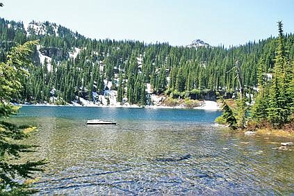
Brad Fuqua/The Western News Bramlet Lake is the picturesque destination at the end of the trail.
Swooping down close to the water’s surface, a bald eagle was the perfect greeting for a first glance of Bramlet Lake. The eagle took its place on a tree at the lake’s far end, joined moments later by its mate.
On the opposite side of the lake, the sight and sounds of snowmelt waterfalls enhanced the picturesque scene. Crystal clear water and the solitude of nature completed the experience.
The Bramlet Lake Trail, located about 32 miles from Libby, heads through both private and Forest Service land. From the trailhead at the gated portion of FR 2332, hikers will climb from 4,700 to 5,600 feet. It appears to be a good trail for those on horseback, although last weekend, a pair of downed trees on a switchback made it impossible for them to pass.
To find the trail, drive about 24 miles from downtown Libby on Highway 2 South. Take a right onto West Fisher Road No. 231. Between five and six miles in, you’ll veer to the left onto road 2332 toward the Lake Creek Campground. At the campground junction, take a right and follow the road. It will become rocky in some spots and those with low-clearance vehicles will need to take extra caution.
As indicated by signage, the trail’s beginning is located on private property, so stay on the path. You’ll come upon a spot where rocks are stacked to mark the beginning of Forest Service land. A sign was posted on a tree just past the rocks but we only noticed it on the way down.
The hike features a steady climb and will be easy for experienced trail blazers and moderate for novices. As of last weekend, the final half-mile of the trail included snow, although it was not difficult to walk over. It took a little more than an hour to reach the lake, but we took our time and stopped a few times along the way to rest and allow horses to pass. The hike back down took about 45 minutes.
Bramlet Lake Trail
Location: Kootenai National Forest
USFS Trail No.: 658
How to Get There: From the eagle on the curve in Libby, drive 24 miles south on Highway 2. Take a right onto West Fisher Road and continue about six miles toward Lake Creek Campground (take a left onto Forest Road 2332 and follow the signs). At the campground junction, turn right and follow the road to the gate and trailhead.
Round-Trip Distance: 2.8 miles
Difficulty: Moderate