Students take project to Philadelphia
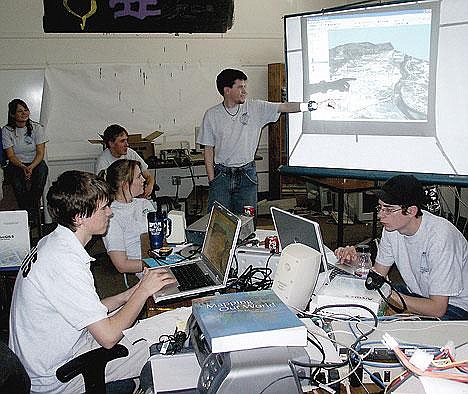
Students in the GIS class at Central School inspect their high-tech mapping project in preparation for a national conference this week in Philadelphia.
By BRENT SHRUM Western News Reporter
A high-tech mapping project by a class at Libby's Central School is being billed as a must-see presentation at the 17th annual National Service-Learning Conference this week in Philadelphia.
The local students' work is listed on a "fast track" of nine presentations out of 150 total that shouldn't be missed by conference attendees, said teacher Dean Herreid.
The Libby project will be included in a series of workshops on emergency preparedness and response. Titled "The Project Model for Enhancing Community Safety Using Geographic Information Systems," the presentation is the result of two years of work by students from both the alternative school and Libby High School who are enrolled in Herreid's GIS class at Central School. Starting with aerial photographs that map the entire Libby area to a resolution of one meter, the students have added layer after electronic layer to the basic map, showing features including topographical contours, flood plains, earthquake faults, roads, schools, apartment complexes, emergency shelters, water wells, food sources, radio stations and internet service providers.
"Pretty much everything you can imagine, we have," Herreid said.
The work started slowly, said student Lorena Mitchell.
"Our first year was a lot of trial and error," she said. "We didn't know what we were doing."
Starting with the basic aerial maps, the students began identifying different types of buildings and then visiting them in person to gather additional information and enter GPS coordinates into the map. Information that was gathered included the building's primary use, its owner, its value, size, construction type, fire suppression, and a point of contact for an emergency, said student Cassi Myslicki.
"Just in case of an emergency, we wouldn't have to scramble for who to contact," she said. "We would have that information."
Much of the students' work has involved seeking out information from diverse sources and adding it as new layers to the map.
"The data is everywhere," Herreid said. "The data is in all these databases everywhere, and these are the data miners."
The students have forged partnerships with agencies including the U.S. Army Corps of Engineers, the Lincoln County Emergency Management Agency, the Department of Homeland Security, Montana Disaster and Emergency Services and the Federal Emergency Management Agency. The project is aimed primarily for use by emergency responders — students have mapped out scenarios dealing with the failure of the city's Flower Creek Dam — but portions can also be made available for other uses, Herreid said. Libby Revitalization Inc. will be using the students' work to create a virtual tour of Libby.
The students have also used the same technology, in combination with Google Earth, to create animated maps showing the locations around the United States where asbestos-contaminated vermiculite ore from Libby was shipped. Those maps are being used by students working on another project, a documentary film about Libby's asbestos tragedy.
Upcoming additions being planned include a layer showing historical wind currents and new aerial imagery for the base with a resolution of six inches rather than one meter.
"It's never done," Mitchell said.